UAVaid
World class, multi-role drones, designed for operations in the worlds remote and difficult to reach areas.

Humanitarian Assistance
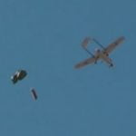
Rapidly deployable capability to provide (1) live aerial video surveillance (2) mapping (3) critical aid delivery. Reconfigurable in-the-field and optimised for large scale natural disasters.
Cargo Delivery
Logistics delivery platform for short-medium-long-very long ranges. Suitable for delivery of wide range of supplies including medical and cold chain to remote and difficult to reach areas.
Mapping
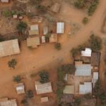
Rapid large-area mapping. Proven in remote Africa, High Resolution images suitable for 2D and 3D map generation. Ideal for climate change mitigation, flood planning, agriculture development, coastal mapping.

Aerial Surveillance
Live streamed aerial video at long range. Suitable for anti-poaching, environmental monitoring, border patrol , evidence gathering and applications needing an eye-in-the-sky.
Contact Us
LATEST POSTS
Happy New Year !!
Wishing all of our customers, partners and friends a very Happy New Year and prosperous 2025.
!! NEW !! Latest SEAWATCH Video
Project SEAWATCH: Autonomous coastal drone AI monitoring collaborative project between UAVAid and Archangel Imaging, with the support of UKRI Future Flight Challenge co-funding.
UAVAID At Farnborough International Airshow 2024
UAVaid is proud to announce its successful participation in the prestigious Farnborough International Airshow 2024. Hosted on the UK Research and Innovation (UKRI) stand 1110, our team showcased the Future Flight Challenge co-funded SEAWATCH project, and networked...
Visit us at Farnborough International Airshow 22 – 26 JULY 2024
UAVAID are delighted to be exhibiting at this year's Farnborough International Airshow, in the beautiful English country of Hampshire, 22 - 26 JULY 2024. On display will be the Project SEAWATCH module, developed with our technology partners, Archangel Imaging. The...
UAVaid Inks MOU With I-Conic Vision for Real Time Disaster Mapping
PRESS RELEASE: UAVAID and I-CONIC Announce Groundbreaking Technology Partnership for To Speed Up Disaster Assessment LONDON and STOCKHOLM – 23 November 2023 In a significant stride towards speeding up the emergency response to large-scale disasters and global...
UKRI Publishes SeaWatch Video
Delighted to be able to announce that UK Research and Innovation have prepared and launched an outline video about Project SEAWATCH. The project is a collaboration between UAVaid and Archangel Imaging to develop a coastal monitoring capability for improving Safety At...